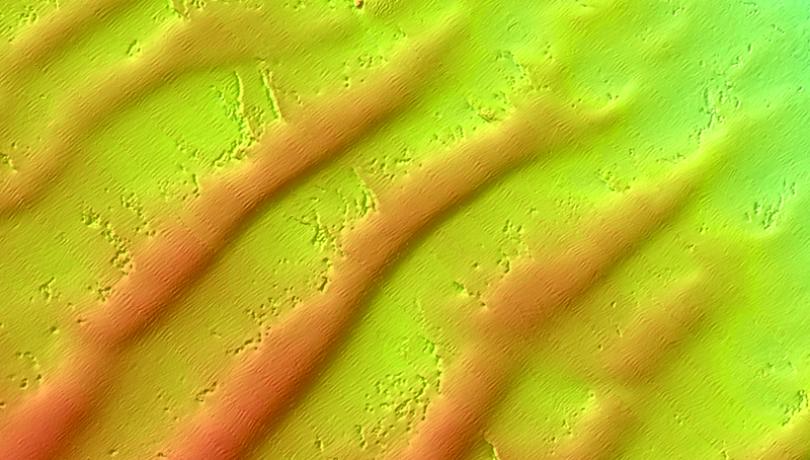
In this month’s “In Depth” section, we explore a new book published by CSIC and Catarata that delves into the processes shaping the underwater landscape—from tectonic forces, volcanoes, waves, and currents to human activities.

It is often said that we know more about the surface of Mars than we do about the ocean floor. This statement is frequently repeated, but that doesn’t make it any less powerful. Water covers more than 70% of the Earth’s surface, yet less than 30% of the seabed has been mapped. We live on a blue planet, but we have barely begun to decipher its submerged geography.
Without technical assistance, humans can only descend to around 40 meters deep. In contrast, the ocean’s average depth ranges from 3,000 to 4,000 meters. The deepest areas, such as oceanic trenches, exceed 11,000 meters. What happens beneath this immense mass of water remains largely hidden—a territory we can barely imagine but which plays a crucial role in maintaining life’s balance on Earth.
In this context, the book Submarine Geomorphology, recently published by CSIC and the editorial house Catarata, offers a journey into this unknown world. It is volume 42 in the “What Do We Know About?” series and has been coordinated by an international team of experts, including Ruth Durán, a researcher at the Institut de Ciències del Mar (ICM-CSIC), who led the publication to bring the underwater terrain closer to the general public through a scientific, visual, and accessible lens.
A geological archive of Earth’s history
The ocean floor acts as a geological archive of Earth's history. It records episodes of volcanic activity, tectonic movements, glaciations, bioconstructions and sediment deposits built up over thousands of years—and increasingly, traces of human activity. This is not a static or uniform landscape, but a dynamic world shaped by processes that occur on timescales ranging from near-instantaneous to geological.
The book clearly outlines a remarkable variety of underwater features: dunes formed by marine currents, submarine canyons, active hydrothermal vents, underwater mountains and volcanoes, glacial terraces, reefs, submerged deltas, and tectonic structures. Through maps and images produced by cutting-edge technologies—such as multibeam sonar systems, autonomous underwater vehicles (AUVs), and remotely operated vehicles (ROVs)—the book offers a visual journey through the planet’s submerged landscapes.
Far from being anecdotal, the study of underwater landforms is essential to understanding key planetary processes. Ocean circulation, sediment transport and accumulation, seismic activity, and the condition of marine habitats are all linked, to varying degrees, to the characteristics of the seafloor. Every structure tells a story: from the ridges of mid-oceanic ranges, where new crust is formed, to abyssal plains, where organic matter accumulates and acts as a carbon reservoir.
The impact of human activity
In addition to its geological and ecological value, Submarine Geomorphology places special emphasis on the increasing impact of human activity on the ocean floor. Bottom trawling, anchoring of large vessels, sediment dredging, construction of underwater infrastructure, and marine resource extraction are leaving visible marks on submerged landscapes. In areas such as the Maresme coast in Catalonia, for example, significant alterations in seabed relief have been observed due to extractive activity.
These kinds of marks are found in many parts of the world—for instance, in the port of Kilmakilloge (Ireland). Off the coast of Tāmaki Makaurau (Auckland, New Zealand), in the North Sea, and in the Gulf of Trieste (Adriatic Sea), furrows have been identified that were carved by ship anchors during mooring maneuvers. Additionally, in regions such as the North Sea, the Baltic Sea, Canada, and the Mediterranean, there is ample evidence of the impact of bottom trawling on the marine floor.
Despite such evidence, the seafloor is still perceived as a distant and disconnected space, almost removed from everyday life. However, what happens in the deep ocean is not irrelevant to what occurs at the surface. The deterioration of underwater habitats, disruption of sedimentary processes, or pollution in abyssal zones can directly affect biodiversity, water quality, fishing, and the resilience of marine ecosystems to climate change.
Beyond outreach
In this sense, the book aims to go beyond simple scientific outreach. It is also a wake-up call to raise awareness. Understanding the ocean floor is the first step toward protecting and managing it sustainably. And to achieve that understanding, science must go hand in hand with technology—but also with social and political commitment.
The book was developed in collaboration with internationally renowned researchers, including Aaron Micallef (Monterey Bay Aquarium Research Institute), Alessandra Savini (University of Milan-Bicocca), and Sebastian Krastel (University of Kiel), all of whom have solid backgrounds in seafloor research across various disciplines.
What emerges from this collective work is an integrative vision of a complex, deep, and fascinating world. A world that, though invisible to our eyes, is part of the same planet we inhabit and deeply influences its balance. As long as the ocean remains a territory in shadow, the mission of research will be to shed light on it. Because what is unknown cannot be protected. And protecting the oceans begins with understanding the shapes, processes, and stories hidden beneath the waves.